
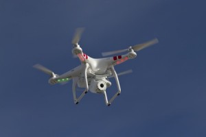
 We’ve all heard about the use of drones for military applications, news gathering purposes, even package delivery, but did you know we regularly utilize them at McNeil Engineering, too? Here’s a quick look at how the DJI Phantom Quadracopter (with a mounted GoPro camera) has made our work easier.
Our goal has always been to give customers a comprehensive view of each and every work site. We know their time is valuable and it isn’t always feasible to keep tabs on ongoing construction. Utilizing a drone has enabled us to take an entire work site and upload it digitally to a client’s computer. By combining aerial videos with our 3D Laser scanning capabilities, engineers and architects can make accurate measurements and decisions, while company owners can view entire projects from the comfort of their own office or home.
The process is relatively simple. We mount a GoPro camera to our quadracopter drone and then make a circular pass of the work area. This takes place during the survey phase of the project and documents everything on the ground. Video recording gives our customers a unique perspective that they wouldn’t receive from 2D renderings, and is great for providing visual answers to questions.
Want to see our quadracopter in action? Check out this video of a recent ALTA survey we completed. If you think our drone would be a great fit for your company’s next project, contact our knowledgable team! Whether you need land surveying, laser scanning, Civil and Structural Engineering, or have a roofing or paving project in the pipeline, we’re here to assist you.