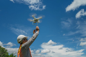
Drones for engineering
 Drones are transforming the architectural, engineering and construction industries. Civil engineering is one of the fastest-changing professions today, and that’s driven mostly by technological development. From 3D modeling software to laser scanning to wearable electronics, technology is making civil engineering more accurate and efficient than ever before.
One civil engineering technology that may surprise you is the increasing use of drones.
It’s a bird, it’s a plane, it’s …
People often think of drones as toys, or in a more covert sense, as tools for espionage or secret military action.
But unmanned aerial vehicles, or UAVs, have transformed architecture, engineering, landscape architecture and construction. And they’re continuing to bring about more changes in the way we work, and in what’s possible to do.
At McNeil Engineering, we began working with drones four years ago. We started with a simple quadcopter equipped with a GoPro camera to help with ALTA surveys (land surveys that conform to the standards of the American Land Title Association). It was a simple machine with a remote control, which made surveying much quicker and more accurate.
We quickly found more uses for it, in construction, asset management and volumetric surveys. And we recognized the potential of this technology for many more uses.
Last year, we upgraded to a larger and more sophisticated drone that extended our capabilities. Rather than needing a remote-control operator, we program the drone’s flight path using an app on an iPad. We then upload the program into the drone and it steers itself, and returns to its launching point when its work is done. Watch it in action.
In addition to land surveys, we use drones equipped with multi-spectral cameras and laser scanners that record millions of data points. This data is then fed into 3D modeling software to create high-quality 3D maps, point cloud models, 2D CAD drawing, 3D models in building information modeling, and more.
Applications
Drones can gather data needed for accurate, detailed maps and models far more quickly than previous methods — and at far less cost than sending a person.
Some of the current applications include:
surveying and mapping
creating 3D topographical maps
inspecting pipelines, roads, bridges, dams, high-voltage power lines, cell phone towers and other critical infrastructure
monitoring progress and safety on construction sites
modeling the amount of fill needed for a project.
Drones today are used in oil and gas development, forestry, mining and agriculture. Increasingly, drones are becoming common on construction sites, too.
Benefits for civil engineering
Today’s drones extend the vision and the reach of the civil engineering team. They produce more high-quality information, images and models than have ever been possible before, and at lower cost.
Sending a programmed drone is much faster than sending a person on foot or even in a vehicle to gather information. The drone operates on its own, freeing up the civil engineering professionals to do their jobs.
We can safely send a drone into a hazardous area, such as a quarry, or tailings pond. Using drones means that people don’t have to climb structures or cross dangerous terrain.
Drone-mounted cameras can take pictures from multiple angles, which can then be processed through specialized photogrammetry software to create digital models.
The practical side
In the United States, commercial operators of remote-control drones must be licensed pilots, with a spotter to help track the movement of the drone. Even with programmable drones, there must be a human being on site to monitor it.
For obvious reasons, drones are not permitted to operate near airports.
And in addition to the UAVs, any civil engineer wishing to take advantage of the technology also needs the full suite of photographic, scanning and modeling software. Getting it all to work seamlessly is no mean feat.
See our drones in flight
Could drones benefit your civil engineering project? Call our drone team and see how we’ve used drones.

