A brief history of land surveying tools
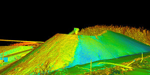
 Surveying has been an essential service to mankind for all of recorded human history. Before one can start any project, buy a plot of land, or even see a plot of land on a map, it must first be surveyed. Because of this, land surveying is believed to be one of the oldest and most important professions in the world. At McNeil, we’re proud to employ the latest in land surveying technology, specializing in 3D laser scanning, which uses a laser to collect tremendous amounts of accurate, dependable data in a short period of time.
This technology has revolutionized the surveying business and is rapidly becoming the standard practice in surveying, making it a viable and cost-effective choice for more and more projects every day. However, as previously mentioned, land surveying is one of the oldest professions in the world, meaning we didn’t always have lasers to collect our data for us. To be able to appreciate the speed and dependability of laser scanning technology, we thought we’d take you through a very brief history of a couple of other tools used historically in land surveying that led the technology to develop to its current level.
1. The Diopter
Far, far before lasers, early Greeks were using a land surveying tool called the diopter. This one is nearly as old as geometry itself, and one of geometry’s first uses was the precise division of land. Dating back to the 1st century C.E., the diopter is a classical tool used to measure angles and altitudes. The diopter was constructed rather simply for how we picture surveying tools today, a disk and a pivot are fixed to a stand and can be adjusted with a screw and a cogwheel to move freely or stay still.
Then, depending on what the device was being used for, it was fitted with either a sighting device or a water level. If the diopter was being used to measure an angle, say to divide the land up accurately, the user would fit a sighting device onto the diopter then adjust the screw so that the disk could move freely. The user would then pick points in the distance to represent the angular separation that needed to be measured (this could be a structure or a tree or a rock, anything they could find.) Then, the user would aim the sighting device at each point, readjust the device so that it remains still again and measure the angle stated on the device! The water level was fitted to determine altitudes, and basically, the user would look at the line of the water, to determine whether objects in the distance were at the same land level as that which the user was standing. The diopter was an incredibly important invention to surveying because it was the first surveying tool that didn’t require the surveyor to physically walk from point to point to measure them, and also didn’t require any extra equipment like chains or ropes.
2. Gunter’s Chain
Speaking of chains, they are one of the most important tools in the history of surveying, so it’s important that we mention them, Gunter’s chain especially. Gunter’s chain was a mathematical tool of measurement invented in 1620 by Edmund Gunter. Gunter’s chain consisted of 100 chain links that were 200 millimeters long, resulting in the full chain being 20.1 millimeters or 66 feet. This tool was incredibly important because it was easily understood by both Americans and English people. There was a way to divide or multiply Gunter’s chain to calculate most pre-existing units of land measurement, for example, ten square Gunter’s chains are equal to an acre of land. This was incredibly helpful because it means that it was the only tool really required to measure land. The physical use of Gunter’s chain was incredibly simple, aside from it being a bit physically taxing. To use it, one simply pins one end of the chain into the ground they want to start measuring and then walks to where they want to stop measuring and places another pin. pins can be placed anywhere along Gunter’s chain and distance can be calculated from there.
We think the history of land surveying is incredibly interesting and we’re so glad to offer our clients simple, fast, and accurate surveying possible at this time in history. We’ve only discussed land surveying, but it’s incredibly important to note that laser scanning can perform surveying of all kinds. Laser scanning surveys an area and everything in it. We use high-definition laser scanners, total stations, and modeling and point cloud software to provide comprehensive, record surveys, 3D CAD models and detailed 2D isometric drawings. This makes laser scanning an incredibly important tool not just for land surveying, but also for building information modeling.
At McNeil, we’re so excited to continue to grow as surveying technology continues to grow. If you’re interested in our surveying, laser scanning, or building information modeling services, please visit our website.

